
In the map view, it is possible to create named locations and geofences. Named location is a specific point on the map; once created, the name assigned to it appears in various reports, for example, thereby facilitating vehicle tracking. Geofence differs from a named location in that alarms can be associated with it, triggering when a vehicle enters or leaves the geofence area
You can create named location or geofence in the map view by navigating to the desired location on the map and right-clicking. This opens a menu that suggests an address for the area being created.
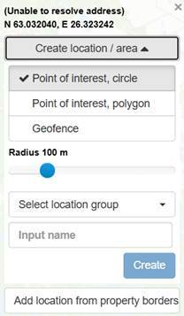
A named location can be created either as a circle or by drawing the specific desired area as a polygon. A geofence can only be created in the shape of a circle. The area can be assigned directly to an existing location group, if desired. Finally, enter a name for the area and click "Create" to save it to the map view.
It is also possible to import ready-made map layers requested by customers into the map view. Currently, the Paikannin.com supports KML and KMZ file formats.